
Weekend Weather Update 2/10/23
- P.J. Gudz
- Feb 10, 2023
- 2 min read

Rain? Snow? A mix? It's all a possibility right now.
A stalled front is draped across the southeast with rain along and south of the boundary and partly to mostly cloudy skies to the north. Eventually, all of north Georgia will be seeing widespread rain as we head into the weekend. Here's the break down.
Over towards the ArkLaTex region (Arkansas, Louisiana, and Texas), a low is spiraling and will eventually dip down to the south towards the Gulf of Mexico. With that movement, this low has the potential to funnel up a lot of moisture from the Gulf Coast and bringing up to North Georgia. As this low spins counter clock wise, it is also ushering in some colder air from the North that will being to spill into North Georgia. Now, overall temperatures are expected to stay above freezing Saturday during the day and then overnight lows Saturday going into Sunday are expected to be right at freezing. Cold temperatures and moisture? Snow. But, the surface temperatures aren't going to be at or below freezing long enough to support a lot of accumulation. Elevations that are higher than 2000' (feet) have the highest potential of any accumulation.
TIMING:
We will being seeing rain for much of the day Saturday and Sunday with clearing skies heading into Monday. However, the timing for possible wintry precipitation is expected overnight Saturday and Sunday.
IMPACTS:


Areas that are outline in red can expect to see precipitation begin as rain and transition to a mix with snow overnight Saturday and into the morning hours of Sunday. Eventually, some areas could see a full transition to full snow. Because of the surface temperatures expected to be above freezing roads should have little impacts except for areas that are higher than 2000' (feet).
This is not expected to last long as temperatures will rebound Sunday afternoon back into the mid to upper 40s. And, for a short while to start the workweek, things will be clear.
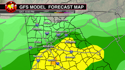
Here are a few models the bigger models we use to show timing and precipitation type:
European Model:


GFS (American) Model:


NAM Model:


Models are coming into agreement more and more as we are getting extremely close to the timing of this system. There are still plenty of uncertainties like where this low is actually going to track. Will a "wedge" form and cause more wintry precipitation? What are the exact totals that North Georgia will get? A small change within the atmosphere can make this weekend go one way or the other. And that's something that The WeatherDawgs team will be watching. We will continue to bring you any forecast updates and continue posting on our Twitter (@wxdawgs) throughout the weekend. Thanks for trusting us to keep you ahead of the storm!

Comments